 Admin
Admin


north.io Elevates Geospatial Data with ISO 19115 Metadata Validation
Background In the realm of geospatial data, metadata plays a pivotal role in ensuring the integrity, usability, and accessibility of information....
Geospatial data, an indispensable element of modern mapping and location-based services, offers a unique perspective on our world.
This article is your essential guide to exploring the aspects of geospatial data: types, coordinates, structures, and formats. We'll show you the power of raster and vector data and explain why coordinate systems matter. Plus, we'll reveal how geospatial data can be your key to mapping, planning, navigation, and groundbreaking research. Whether you're a GIS professional or new to the field, this is your passport to the geospatial world.
Geospatial data is data with a unique location on Earth. It can include information about physical features, such as landforms, bodies of water, and vegetation, as well as human-made structures, such as roads, buildings, and public transport. Geospatial data can be collected in a variety of ways, including satellite imagery, aerial photography, and ground surveys. The data is commonly represented as one of these two types: raster and vector.

Image: The left panel shows the three types of vector data: point, line, and polygon. The right panel shows the same data translated into a raster format (Image source). Data can be converted from vector to raster and vice versa, but the nature of the data will be very different and depends on the conversion algorithm.
💡Independent of the data type, knowing the coordinate reference frame is utterly important to plot the data in its correct location! Without any reference information, spatial data becomes useless.
TrueOcean and TrueEarth automatically geo-index uploaded data and store this information with each data file. This index is used to make data findable and accessible, e.g. in the search function. By default, TrueEarth and TrueOcean recognise the type of data during upload to support also inexperienced users in using and understanding their geospatial data.
Geospatial data provides a location for the stored information in a coordinate frame (spatial reference system) representing the Earth’s surface. There are two types of spatial reference systems:
For referencing, map projections are commonly indexed using the EPSG catalogue (EPSG) or indicated as WKT information (OGC WKT).
💡 While EPSG are commonly used and cover most of the global and regional reference frames, very specific local reference frames need to be defined as WKT. Each EPSG catalogue entry can be linked to a WKT string, but not every WKT can be linked to an EPSG catalogue entry.
TrueOcean and TrueEarth use the Pseudo-Mercator map projection EPSG:3857. This is indicated in the map view at the bottom right. They translate any uploaded geospatial data into the projection of its map view (also Pseudo-Mercator, EPSG:3857). Already in the file preview, the user can check the position of the data and data quality. This provides the necessary consistency in large and growing projects.
❗CAUTION: The maps are only correct in angles and shapes. However, distance and area measurements should exclusively be conducted using the built-in measurement tools that convert the projection distortion.
Geospatial data can be structured in a variety of ways, depending on the type of data and the intended use. However, some common ways to structure geospatial data include:
TrueEarth and TrueOcean leverage a scalable geo-cloud architecture to handle big data from satellite imagery to complex 3D point cloud data. Data are stored and managed either on centralised servers (e.g., IONOS) or in a decentralised, distributed manner. Using open-source components ensures interoperability and allows users to work across multiple projects on one single platform.
👉TrueOcean translates the majority of available marine data structures in a standardised manner to make the data FAIR and to foster standard quality control procedures. TrueEarth standardises typical land survey data and offers tools for processing and analysis of these data.

Image: TrueOcean Marine Data Platform - Map view with geospatial data
When choosing a way to structure geospatial data, it is important to consider the following factors:
💡 While shapefiles (.shp) are still the most commonly used format, there are several reasons why this format is outdated. Alternative file formats to be considered are Geopackage and Geoparquet.
TrueEarth and TrueOcean convert large data files (e.g., point clouds) into Parquet files, which reduces the file size dramatically optimising it for cloud applications. The project data overview automatically structures data after upload and visualises even complex data structures.
👉 TrueOcean optimises workflows dealing with marine data formats, e.g. from multibeam echosounders. TrueEarth supports file formats typically used in land surveys, such as drone video footage or LiDAR data.
Once the geospatial data has been structured, it can be used for a variety of purposes, such as:
TrueOcean and TrueEarth streamline large data volumes. Their modular setup provides a high degree of flexibility for fitting workflows to individual needs and to a certain purpose. With innovative tools users are enabled to analyse complex data on their own. Map views can be managed, modified and shared simply via a browser interface.
Geospatial data provide a valuable basis for a variety of purposes. By carefully structuring geospatial data, it can be made more accessible, easier to use, and more valuable.
Geospatial data are visualised and organised in Geographic Information System (GIS) software for a variety of purposes, including mapping, planning, and addressing research questions. The most common commercial GIS software is ArcGIS by ESRI; the most common open-source equivalent is QGIS. GIS software organises geospatial data in feature layers (vector data) or raster layers (raster data). The style of layers can be exported with a feature or raster layer as a layer file (.lyr) for ArcGIS or a layer style file (.qml) for QGIS.
GIS developed from individual desktop-based use and data storage is typically limited to desktop or server solutions. For this, GIS projects refer to direct data paths or relative data paths. Cloud solutions and multi-user projects become increasingly popular: ESRI offers its ArcOnline tool, now; an open-source equivalent does not exist, so far.
Common GIS softwares offer a vast variety of tools to visualise, modify, analyse, and export data.
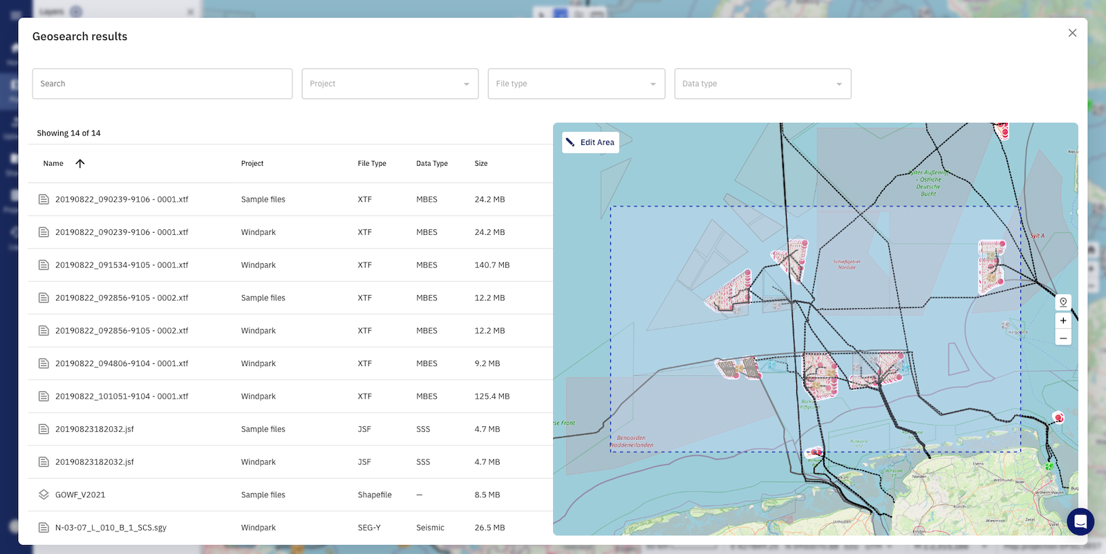
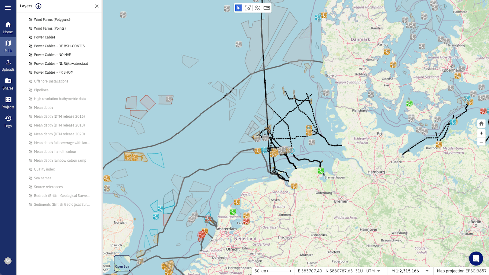
Image: Geospatial search functionality in the TrueOcean MDP
TrueOcean and TrueEarth optimise data management in large multi-user, multi-sensor projects. Their unique GeoSearch technology offers a new way to find geodata across multiple projects and based on their true location. Stop looking, start finding.
Author
Meike Klischies, Research Project Manager at north.io

Background In the realm of geospatial data, metadata plays a pivotal role in ensuring the integrity, usability, and accessibility of information....

Kiel, 06.02.2024. north.io GmbH, a dynamic force in the geospatial industry, proudly announces its recognition as one of the Global Top 100...

In today's fast-paced ocean industry, the ability to efficiently manage and locate hydrographic survey and underwater inspection data is crucial. The...
Watch the Video In a world where vast amounts of data drive decision-making processes, managing, and organising complex datasets is crucial, even...